
How much rain did your area get in Kansas City storms? See rainfall totals in this map
AI-generated summary reviewed by our newsroom.
- Powerful thunderstorms dropped 1 to 3 inches of rain across the Kansas City metro.
- Flash flooding occurred on I‑35, Metcalf Avenue, Roe Ave near W 75th and Shawnee.
- StormWatch gauges recorded a high of 3.16 inches near I‑435 and Kaw Drive in KCK.
Powerful thunderstorms swept through Kansas City early Thursday, dropping 1 to 3 inches of rain in a relatively short time and causing flash flooding in some parts of the metro area. The downpours prompted the National Weather Service to issue a flash flood warning for much of the Kansas City metro. That warning has since expired.
Flooding was reported in several areas along Interstate 35, near Shawnee Mission North High School, several areas along Metcalf Avenue and on Roe Avenue near West 75th Street in Johnson County. Flash flooding was also reported on East 63rd Street and Interstate 435 south of Missouri 350, according to local storm reports.
Reports indicated street flooding near East Banister Road at Holmes Road and Lydia Avenue, with vehicles stranded. A water rescue was reported near Interstate 49 and Blue Ridge Boulevard in Grandview.
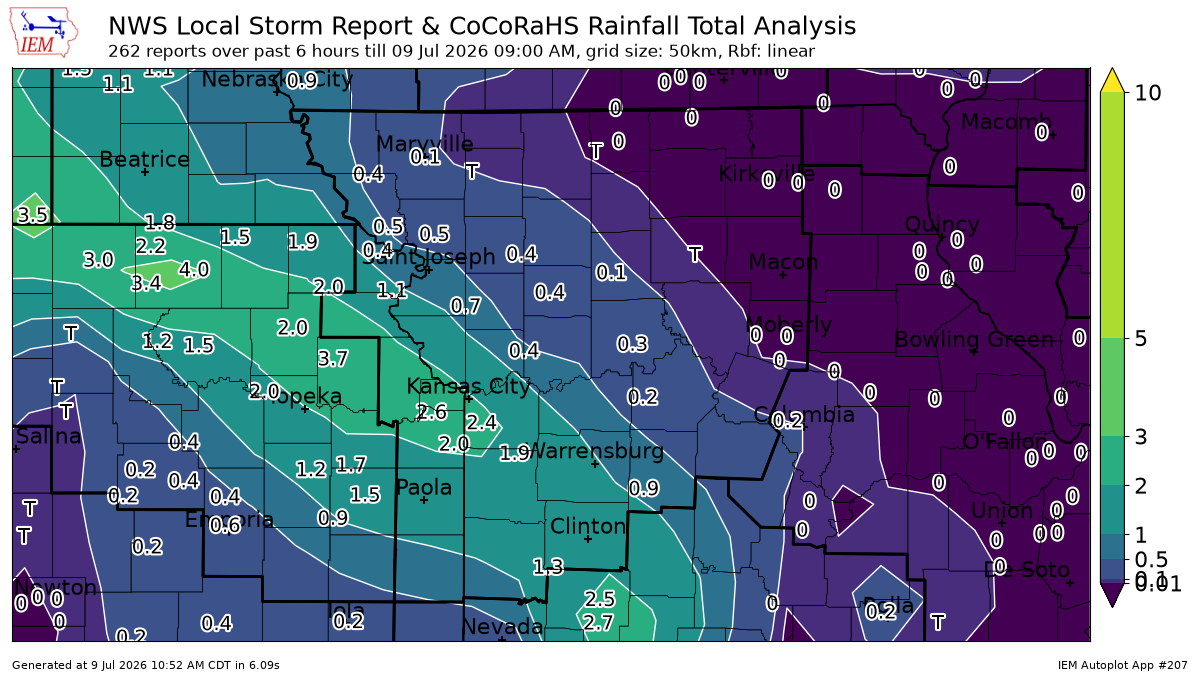
Kansas City area rainfall totals
Close to 1.25 inches of rain fell at Kansas City International Airport (MCI) during six hours that ended at 9 a.m., according to an automated weather station system report.
Meanwhile, 1.24 inches fell at Kansas City Downtown Airport – Wheeler Field, 1.97 inches at Kansas City-Lee’s Summit Regional Airport, .78 of an inch in Clinton, .38 of an inch in Sedalia and .32 of an inch in St. Joseph.
In Kansas, 1.02 inches fell in Lawrence, 1.87 inches at New Century AirCenter in Olathe and 1.30 inches at Johnson County Executive Airport in Olathe.
According to StormWatch, a collection of rain gauges across the metro, the heaviest rain fell in Johnson and Wyandotte counties.
The highest amount was 3.16 inches of rain reported near Interstate 435 and Kaw Drive/Kansas 32 in Kansas City, Kansas, during the six-hour period that ended at 9 a.m. About 2.60 inches of that total fell in the first three hours.
Other significant rainfall totals included 2.88 inches near North 139th Street and Leavenworth Road in Kansas City, Kansas, 2.84 inches at Nall Avenue at Brush Creek in Prairie Village and 2.8 inches at West 69th Street at Turkey Creek in Merriam.
Here’s an interactive map of where the heaviest rain fell across the metro.
Another round of storms could redevelop Thursday afternoon and evening, brining another chance for severe weather and more heavy downpours.
