How highways decimated Kansas City’s West Side over decades of development
Between 1950 and 1980, the population of Kansas City’s West Side community dropped from more than 14,000 to just 5,500. In 1972, the Department of Housing and Urban Development declared the neighborhood no longer viable as a residential community. For many, the cause was clear: the highways.
Ahead of the next Reconnecting the West Side community summit on Saturday, Aug. 2, at the Tony Aguirre Community Center, the KCQ team at the Kansas City Public Library took a look at the history of the West Side — and the highways that came to divide it.

Like many urban neighborhoods, the West Side began as a fashionable residential suburb. By the 1920s, it had become a solidly working-class and ethnically diverse community. While wealthier residents were moving south to new developments like Hyde Park and the Country Club District, thousands of Mexican migrants, fleeing the violence of the Mexican Revolution, settled primarily in the West Bottoms and the West Side, the latter of which has remained the heart of the city’s Hispanic community.

Hunger for a KC thoroughfare
Not coincidentally, as wealthier Kansas Citians moved southward, the idea for a “southwest trafficway” gained momentum. City officials embraced a plan to run a wide traffic artery directly through Penn Valley Park, extending south to Brush Creek and connecting to the Country Club District and expanding suburbs of Johnson County.
At the time, many questioned the need for such a major roadway. Jacob Werby of the South Main Street Improvement Association argued in 1928 that it would “do nothing but create a speedway between the business district and the Country Club District.” Why, he asked, should the entire city pay for a traffic artery “leading to a district in which not more than five percent of the city’s population lives?”
In the decades that followed, however, the Country Club District boomed, and the once-questioned commuter route became a central thoroughfare, realizing the vision of its planners but at great cost to the neighborhoods in its path.

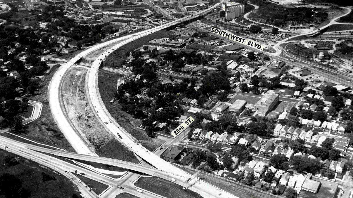
City leaders advocated a “thoroughly modern” viaduct for the route between 14th and 26th streets, noting that the concept of designing roadways to accommodate high-speed, high-volume traffic had “recently taken hold in the country.”

Viaduct takes hold
Though still relatively new, by the postwar years the concept of high-speed, high-volume roadways had become a planning consensus. As The Kansas City Star noted in 1944, “a federal super highway through Kansas City’s West Side probably will be demanded.” Planners ultimately settled on a route along Summit Street, and construction began in 1949.
Construction of the viaduct alone displaced an estimated 543 West Side residents. One of them, Patrick Fleming of 2539 Summit, told the Star, “When I built this house forty years ago, I thought I’d be here the rest of my life … Along they come and take it away from me and give me $4,250. Now I’m too old to get a job, and where can I get another house for forty-two fifty?”

The viaduct officially opened in November 1950. At the ceremony, a Star reporter spoke with the drivers of the first two cars in line. Fittingly, neither was local — one had driven in from Lee’s Summit, the other from Shawnee.
The trafficway became a model for a new era of freeway construction in American cities — routing highways straight through urban neighborhoods — and it wasn’t long before West Side residents once again found themselves in the shadow of the wrecking ball.
Interstate 35 is born & more residents displaced
Just a year after the viaduct opened, the City Plan Commission released an engineering report calling for a network of expressways to and through the city center, including a series of new highways cutting through the already struggling West Side.

While right-of-way clearance was underway for the westernmost section of the downtown loop — known as the West Freeway — cutting through the West Side and Quality Hill, the neighborhood simultaneously found itself in the path of another so-called “federal super highway”: Interstate 35.

By 1958, I-35 was approaching Kansas City from Johnson County, and city officials were eager to connect it to the newly opened Southwest Trafficway, which would need to be widened from six to nine lanes.
I-35 construction faced numerous setbacks but by the mid-1960s, The Star projected that “a businessman will be able to leave his home in Roeland Park, Kansas, and drive to Downtown Kansas City in less than eight minutes.” It was later estimated that about 1,000 residents of the West Side South were displaced in service of this lofty goal.
Decline of the neighborhood
Meanwhile, the West Freeway cut through Quality Hill and West Terrace Park, one of the city’s first public green spaces, and leveled 12 city blocks in the West Side North to make way for the massive Quality Hill Interchange.
Even highway department officials, who by 1963 were offering advisory relocation assistance, couldn’t say how many residents would be displaced by the interchange, but they estimated at least 2,000 people, mostly families.
The condemnation of roughly 17 acres of West Terrace Park was a particularly bitter pill for residents to swallow. Parks Superintendent Frank Vaydik proposed using the revenue from the land sale to replace park facilities elsewhere on the West Side.

By 1971, however, more than $500,000 of the $800,000 received from the land sale had been spent in other parts of the city. At a community meeting, an assistant parks director attempted to reassure West Side residents that part of the remaining $300,000 had been earmarked for cleaning Penn Valley Lake. One resident sharply replied that Penn Valley Park, cut off from the community by Southwest Trafficway, no longer functioned as a neighborhood park.
It was in April 1972 — six months before the opening of the West Freeway and the completion of the downtown loop — that HUD halted approval of any new construction applications in the West Side, declaring the area “no longer viable as a residential community.”

In the midst of their ongoing struggle to keep their neighborhood alive, a predictable tragedy galvanized West Side residents. On Friday, Feb. 17, 1978, a fast-moving car struck and killed 70-year-old Theodore S. Sanchez as he attempted to cross Southwest Trafficway.
West Side residents had long warned that the push-button crosswalk was inadequate for safely reaching the northbound bus stops in Penn Valley Park, and within a week of the tragedy more than 400 people had signed a petition urging the city to take action.
The city approved a pedestrian bridge at 29th Street that included landscaping, weather protection and wheelchair access. However, citing budget constraints, a scaled-back version of the bridge lacking these features was ultimately constructed in 1980.

I-670 lands another blow to West Side
Despite growing public opposition to urban highways, plans dating back to the early 1940s moved forward for one last superhighway through the West Side. Interstate 670 was designed as a second intercity viaduct extending the southern portion of the downtown loop — also known as the Crosstown Freeway — westward through the West Side and the West Bottoms before crossing the state line to connect the two Kansas Cities.
The proposed Missouri section of I-670 called for a massive cut through the historic bluff where William Mulkey built one of Kansas City’s first brick residences in 1857. The project would displace around 200 hilltop residents, many of whom urged the city to explore tunneling through the bluff rather than removing it entirely.

A study group of five West Side residents and five city officials developed an I-670 plan “that will do the least damage to the community.” But in the end, their recommendations fell on deaf ears. While residents of the Polish Hill neighborhood in Kansas City, Kansas, successfully forced a rerouting, the planned cut through the Mulkey Square bluff proceeded, displacing 78 families and 13 businesses.
Communities disconnected
When the tunnel plan failed to catch on, the advisory group could only advocate for pedestrian access along two bridges in the hope of keeping the community connected.

Despite the pedestrian bridges, the section of Mulkey Square north of the cut withered. Today, not a single home remains on the hill. The entire Missouri section of I-670 took nearly a decade to finish and cost $54 million, nearly $17,000 per linear foot.
This week, city officials are asking residents to help shape solutions for addressing the lasting harm caused by urban highways. West Side residents who want their voices heard are encouraged to attend the second Reconnecting the Westside Community Summit on August 2, from 10 a.m. to noon, at the Tony Aguirre Community Center.
This story was originally published July 27, 2025 at 5:00 AM.