
Damaging winds, heavy rain possible as storms move toward Kansas City
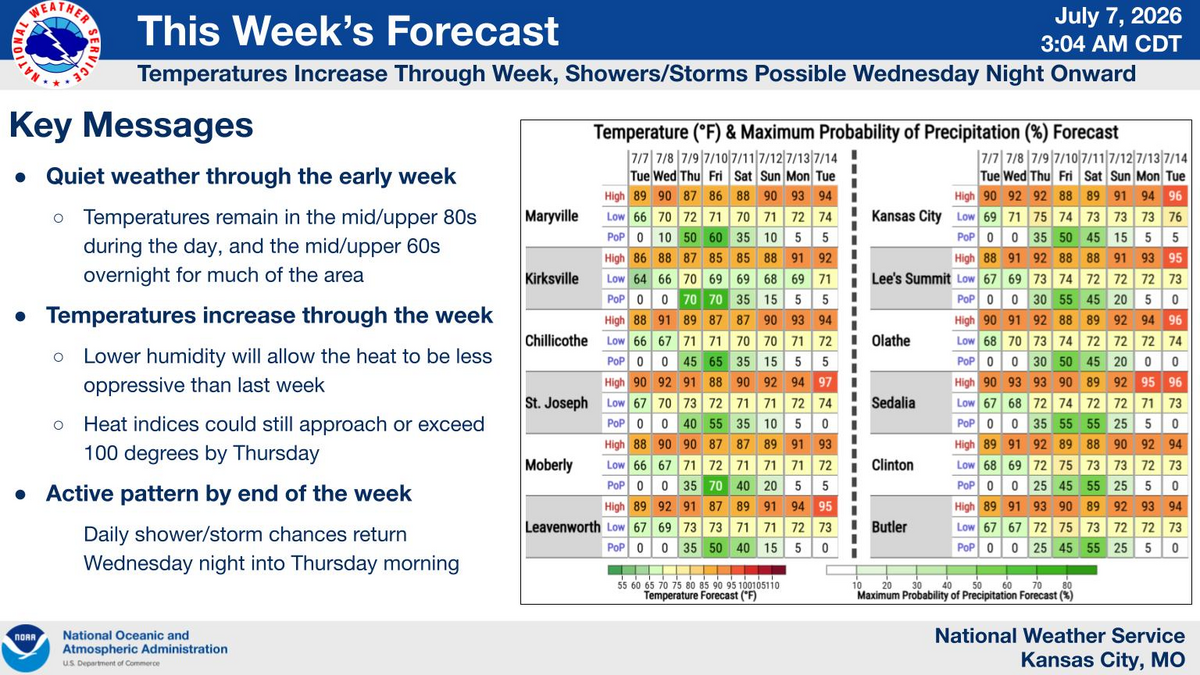
Kansas City’s quiet stretch is ending. Wednesday may be one of the last dry days this week before storms return, with some capable of damaging winds and heavy rain, the National Weather Service said.
Forecasters expect mostly sunny skies Wednesday, with temperatures reaching into the lower 90s. Typically, the metro sees high temperatures around 88 degrees this time of year.
Clouds will likely start to build in from the northwest in the evening ahead of the next weather system. A cluster of strong to severe thunderstorms will be possible late Wednesday night into early Thursday, primarily across northeast Kansas and northwest Missouri, the weather service said.
These storms will be capable of producing damaging wind gusts up to 60 mph and heavy downpours. Hail up to 1 inch in diameter is also a lower possibility. Areas west of Interstate 35 could see excessive rainfall, the weather service said.
The environment looks more favorable for the severe weather over Nebraska and Iowa. Still, the cluster of storms could clip parts of the Kansas City forecast area as they dive south from southeast Nebraska.
The Storm Prediction Center, part of the National Weather Service, has issued a slight risk (Level 2 of 5) for far northwest Missouri. Meanwhile, areas mainly west of I-35 and north of the Kansas City metro are under a marginal risk (Level 1 of 5).
The Weather Prediction Center, also part of the National Weather Service, has issued a slight risk (Level 2 of 4) for excessive rainfall over the northwest portion of Missouri and a marginal risk (Level 1 of 4) for areas mostly along and west of U.S. 65 across central Missouri.
Storms early Thursday should weaken as the morning system falls apart and moves east, leading to what could be the hottest day of the week. If clouds clear out, the metro could heat up to near 90, with heat index values around 100 to 104, especially south of I-70, the weather service said.
The morning storm activity will heavily influence evening storm chances. If the atmosphere destabilizes, a few pop-up thunderstorms could form near the Kansas City metro area late in the afternoon.
If that destabilization doesn’t happen, storms may initiate a bit further east of the metro, near U.S. 65 and Interstate 70 over north-central Missouri.
“Wherever these storms decide to initiate, they will signal the start of the next round of severe weather for our area,” the weather service said.
This round of storms could merge into a bigger cluster of storms as it moves east. The Storm Prediction Center has placed a large portion of Missouri just east of the metro under a slight risk (Level 2 of 5) of severe weather. Meanwhile, Kansas City and the surrounding areas are under a marginal risk (Level 1 of 5).
Forecasters said these storms could produce damaging wind gusts up to 70 mph and heavy rain. One-inch hail will also be a possibility.
The cluster of storms is expected to be similar to the July 4th storms complex that moved through the region, which knocked out power, according to the weather service.
The weather service urged people to have multiple ways to receive warnings in case power outages occur again, and to prepare for severe weather at night.
Rain chances will linger into the weekend, with a 30% to 60% chance for Friday, with the highest chance occurring overnight. Then there’s a 30% to 40% chance of rain for most of the day on Saturday. Strong to severe storms may be possible again on Friday, primarily south of I-70.
On Sunday, there is a 15% to 30% chance of rain, with the chances decreasing throughout the day.
Forecasters expect rainfall totals from Wednesday through Sunday to be widespread, ranging from 1 to 3 inches, with the heaviest amounts falling north of I-70. Some areas in northeast Missouri could see higher amounts.
The rain and clouds moving will help keep weekend temperatures a bit cooler — in the upper 80s. Forecasters expect next week to be hot and dry, with temperatures building back into the mid-90s.
