
From sunshine to storms: How much rain is headed to Kansas City?
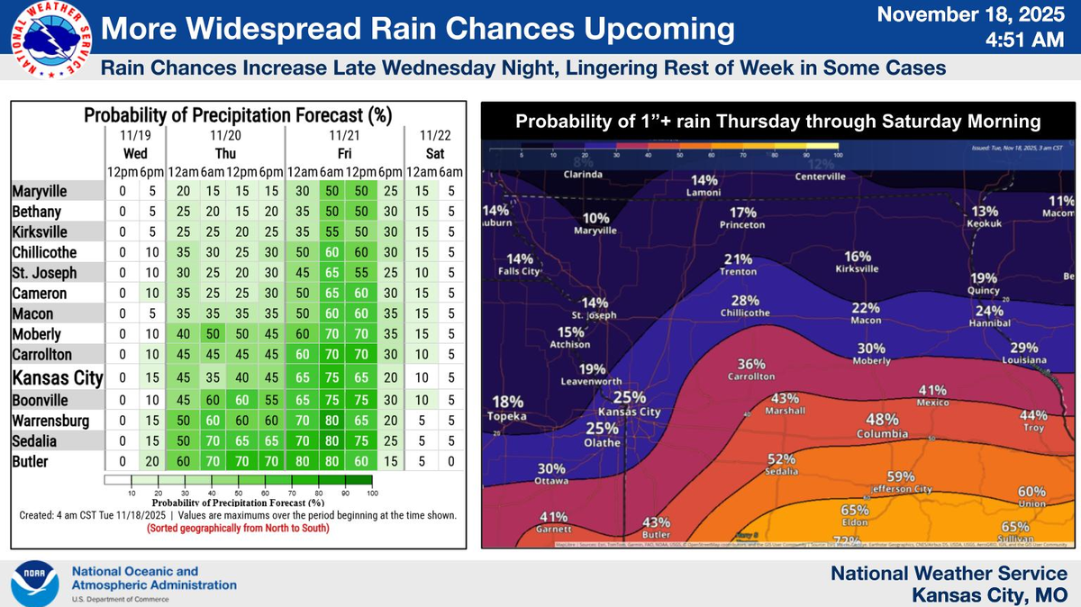
Enjoy the calm sunshine while it lasts. Rainy days are ahead for the Kansas City area, with up to two inches of rain possible by the end of the week, according to the National Weather Service.
“Quiet and largely pleasant conditions will prevail today (Tuesday) as winds gradually shift from southerly to northerly across the area,” the weather service said.
Expect skies to clear across much of the area, with the possible exception of northern Missouri, where cloud cover could linger. Temperatures will range from the mid-50s in the northwest to around 70 degrees in the southeast.
In the metro, temperatures will be around 65 degrees, which is considerably warmer than the average of 52 degrees typically found in mid-November.
The weather is expected to remain quiet on Wednesday, but clouds will build back in as the next weather system approaches the area, according to the weather service. Temperatures will be slightly cooler, reaching a high of around 60 degrees.
The weather is expected to take a turn on Wednesday night, when rain is expected to move into the area.
By Thursday, the best rain chances are expected to be near or south of Interstate 70 before spreading further northward overnight and into Friday, the weather service said. The greatest total rainfall amounts will also be found south of I-70, where an inch or more is possible.
Although the forecast has been trending slightly drier than Monday, some areas could still see over an inch of rain, the weather service said.
“That said, best chances for appreciable rainfall remain along/south of I-70, where probabilities for an inch or greater tend to be around 40% or greater,” the weather service said. “Amounts tend to taper off northward, especially into far northern Missouri and southern Iowa.”
In the metro area, there’s a 25% probability that rainfall will exceed an inch from Thursday through Saturday morning.
Temperatures are expected to cool due to the rain, returning closer to seasonal averages by Friday.
Rain chances diminish heading into Saturday, allowing temperatures to warm into the mid-50s on Saturday and near 60 on Sunday and Monday. Skies are also expected to be partly to mostly sunny over the weekend.
The next chance for rain arrives on Monday night and continues into Tuesday.
This story was originally published November 18, 2025 at 8:13 AM.
