
‘Kitchen sink’: Wild weather bringing thunderstorms, snow, blizzard to KC. Here’s when
A powerful, multi-threat storm is moving into the Kansas City region Tuesday, and it is expected to bring a mix of wild weather, including the possibility of a blizzard, the National Weather Service said.
This storm has so many potential hazards that weather service meteorologists are dubbing it “the kitchen sink.” They have used the hashtag “TheKitchenSink” on social media and “The Kitchen Sink” as a headline in a graphic.
So what can the metro expect? Moderate to heavy rain, possible severe thunderstorms, strong winds, snowfall and potential blizzard conditions, the weather service said.
“A brief tornado or two can’t be ruled out, although this is unlikely,” the weather service said.
Widespread rainfall first in KC’s forecast
Rain from the strong storm system began falling in the Kansas City area before the morning rush hour on Tuesday.
The rainfall is expected to become widespread, with a few thunderstorms possible, the weather service said.
An isolated strong to severe thunderstorm is possible in the afternoon. Meteorologists say the main threat will be damaging winds and hail, while the tornado threat is low.
The weather service’s Storm Prediction Center has placed most of the Kansas City forecast area under a marginal risk of severe weather.
Between 1 and 2 inches of rainfall is expected, with some areas seeing more than 2 inches of rain.
“Rainfall rates should not be too high, with these rain totals occurring over a relatively long period of time,” the weather service said. “ Thus, flooding concerns are not particularly high at this time.”
However, fast-responding creeks like Stranger Creek in Easton in Leavenworth County could crest into a minor flood stage.

Snow, howling winds expected to have highest impact
The weather service said that a cold front would come crashing through the area Tuesday night, and dangerous northwest winds would build behind the front. Wind gusts of 60 to 70 mph are likely behind the front, especially across eastern Kansas and western Missouri.
“Now for what is expected to be the highest impact weather from this system — snow and extremely strong winds,” the weather service said.
Cold air will also rapidly fill in behind the front, causing rain to transition into snow, the weather service said.
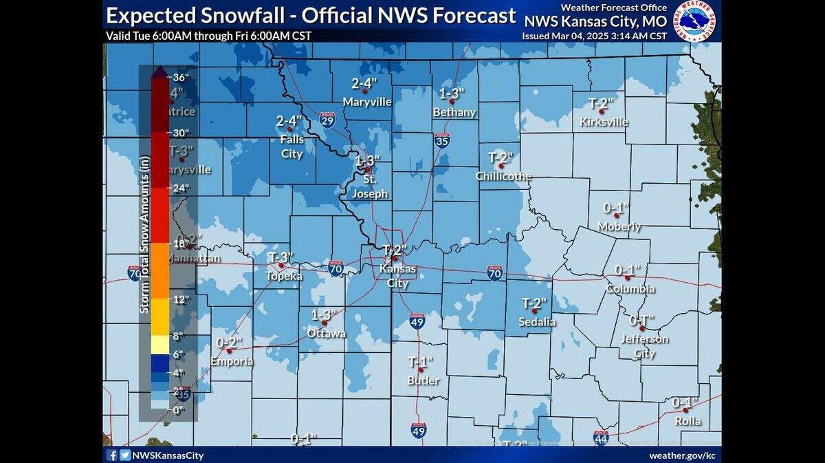
Minor accumulations are expected. In the metro, a dusting to 2 inches of snow is possible, while areas across extreme northeast Kansas and northwest Missouri could be blanketed in 2 to 4 inches of snow.
Blizzard warning issued for Kansas City area
The weather service has issued a blizzard warning for parts of east, central and northeast Kansas and north, central, northwest and west-central Missouri, including the Kansas City metro area.
“Again, want to continue to hammer the point that there is no minimum snowfall accumulation requirement for a blizzard warning,” the weather service said. “Snow totals are not expected to be that high, but with snow and winds gusting to 60 plus mph, at least 3 hours of visibility of quarter mile or less seems likely.”
That three-hour period is the key, as a blizzard is defined as three hours or longer with sustained wind or frequent wind gusts of at least 35 mph and considerable falling and/or blowing snow that frequently reduces visibility to under a 1/4 mile.
For the metro area, blizzard conditions are expected as winds gust up to 70 mph between 9 p.m. Tuesday and 5 a.m. Wednesday.
Whiteout conditions are expected, which will likely make travel extremely hazardous. The weather service said that travel should be restricted to emergencies only.
The strong winds could cause extensive tree damage.
“Very strong northwesterly winds continue after the snow ends, and the high wind warning/wind advisory goes through 6 p.m. Wednesday,” the weather service said. “Power outages will definitely be possible given the long duration of very strong winds.”
Temperatures to rebound for the weekend
Warmer weather is expected on Thursday, with temperatures climbing to the mid-40s, the weather service said. Typically, Kansas City sees temperatures around 50 degrees this time of year.
Light snow will be possible overnight in northern Missouri, near the Iowa border.
Temperatures will be a couple of degrees warmer on Friday and Saturday, around 50 degrees.
Much warmer weather is expected to end the weekend, with temperatures in the mid-50s on Sunday and near 68 on Monday.
This story was originally published March 4, 2025 at 7:50 AM.
