Chiefs Super Bowl parade map shows street closures, bathrooms and lost child centers
Update: The Kansas City Sports Commission issued a correction to its parade map. The corrected map shows 17th Street will be closed.
A parade route map released Tuesday by city officials shows attendees where facilities are located, where to find medical help and where parents can go to find lost children.
The parade is scheduled to begin at 11:30 a.m. Wednesday, beginning at Sixth Street and heading south on Grand Boulevard, through downtown and past the Sprint Center. The route turns west on Pershing Road and ends at Union Station, where a victory rally will be held with Chiefs players at 1:30 p.m.
The event celebrates the Chiefs’ victory over the San Francisco 49ers in Super Bowl LIV. The Chiefs won by a score of 31-20.
About 2 p.m. Tuesday, the city will start blocking off Grand and streets that run east and west between Walnut and McGee from the Berkley Riverfront to Pershing. Until 4 a.m. Wednesday, vehicles can cross at four intersections.
Parade attendees can find bathrooms about a block east or west from the parade route every couple blocks.
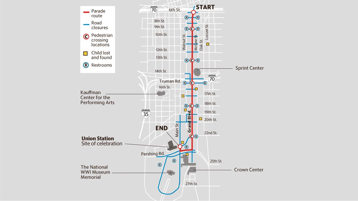
There are five pedestrian crossings along the parade route on Grand: Ninth Street, 13th Street, Truman Road, 18th Street and 22nd Street.
There is an accessible viewing station with a video screen on the southeast corner of the National WWI Museum and Memorial grounds.
Several child reunification stations are positioned throughout the route, including two temporary tents.
Other locations are at the Kansas City Police Department, Church of the Resurrection, Blue Cross and Blue Shield Kansas City and Lunchland at Crown Center.
The map also shows one medical center near the National WWI Museum, though city officials said Tuesday there will be several medical tents with green flags spread throughout the route.
To view the parade map, head to the Kansas City Sports Commission and Foundation website.
This story was originally published February 4, 2020 at 11:46 AM.