Expect a soggy weekend in Kansas City. Here’s how much rain is expected and when
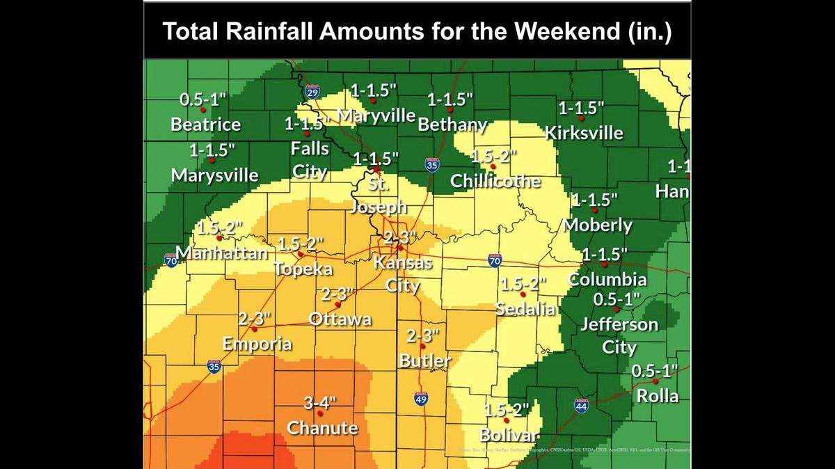
After a pleasant fall day Friday, Kansas Citians can expect consecutive rainy days this weekend and into next week, according to the National Weather Service in Kansas City.
Friday will be mostly sunny with a high near 62 degrees, according to the NWS forecast. Then an abnormal amount of precipitation for this time of year is possible over the next few days. The threat of severe weather is minimal, though.
Parts of the Kansas City metro could see up to 1 and 1/2 inches of rain on Sunday alone, the weather service said in its Friday forecast discussion.
“The atmosphere is expected to be able to hold concentrations of moisture considered abnormal for this time of year Saturday night through Tuesday,” the weather service said.
Weather models are showing a 90% chance of rainfall exceeding 2 inches through that 72-hour period in central and eastern portions of the metro. There is an 85% chance that rainfall amounts exceed 3 inches in that same time frame with the most rain concentrated along Interstate 49.
Temperatures Saturday are expected to be slightly above normal for this time of year, but cooler air is making its way to the region, the weather service said. The high for Saturday is around 62 degrees.
Earlier this week, the metro saw above-average temperatures for late October.
Kansas City’s weekend weather forecast
Showers are likely mainly after 1 p.m. Saturday. That evening, there is a slight chance of a thunderstorm, according to the forecast.
Showers and a possible thunderstorm are also likely Sunday, with a high near 68 degrees. On Sunday night, there is another chance for a thunderstorm and a low of around 62 degrees.
Weather models predict a 15% chance of severe weather from 7 a.m. Monday through 7 a.m. Tuesday, the weather service said. But the threat remains minimal.
Temperatures will remain slightly above average for this time of year through Monday, then cooler air will bring temperatures down beginning Tuesday, the weather service predicts.
Monday, showers and thunderstorms are expected with a high near 68. Monday night, a thunderstorm is possible before 1 a.m.
On Tuesday, showers and a thunderstorm are possible mostly before 1 p.m. The day’s high will be near 57 degrees.