Kansas City was devastated by the 1951 flood. Learn how it still shapes our city today
Seventy-Five years ago this month, Kansas City experienced its worst natural disaster when the swollen Kansas (Kaw) River topped the levees protecting industrial districts and communities on both sides of the state line. Two months of heavy rainfall resulted in then-unfathomable devastation that still reverberates today.
KCQ looks back at the 1951 Flood ahead of a new Kansas City Public Library exhibition, “Hell and High Water,” which opens at the Central Library on July 11.
Black Friday
Flooding began on the evening of July 12, 1951. The following day, July 13, saw such destruction that it earned the name Black Friday.

From May through July, monthly rainfall totals in Kansas and Missouri were three to four times higher than usual. Locals joked about building arks, because in some areas it had literally rained for 40 days and 40 nights. Between July 9 and July 13 alone, parts of the Kansas River basin received 18.5 inches. Unable to hold any more water, the banks of the Kaw began to overflow.
Flooding started in Hayes, Kansas, and moved east through, Manhattan, Topeka and Lawrence, inundating thousands of homes, businesses, and farms as it headed for the confluence of the Kansas and Missouri rivers between Kansas City, Kansas, and Kansas City, Missouri.

The U.S. Army Corps of Engineers had spent weeks reinforcing the levees upriver from Kansas City and assured the public they would hold. But on the morning of July 12, as the Kansas River rose, officials began to plan for the worst.
City officials warned residents in the vicinity of the dikes to prepare to evacuate. Sewers on both sides of the state line began to back up, leaving water standing in low-lying streets and covering railroad tracks.
Around 10 p.m., the evacuation sirens sounded for southern KCK. Shortly thereafter, water began pouring over the 40-foot-tall levees, first in the Argentine neighborhood, then in Armourdale. When dawn broke Friday morning, both had become one giant lake.
.jpg "2. Aerial View of Confluence (10020156).jpg")
As the day wore on and the water continued to rise, events happened in quick succession.
Municipal Airport (now the Kansas City Downtown Airport) was still dry, but no one knew how long that would last. Across the confluence on the Kansas side, water surged quickly around the Fairfax Airport. Pilots from both sites flew their planes to safety in Grandview, Mo.
Those in the West Bottoms—then called the Central Industrial District—scrambled to outrun the water. Stockyards staff herded as many animals as they could into overhead chutes. Workers raced to move equipment, goods, records, and supplies to upper warehouse floors.

Nearby, floodwater inched up Southwest Boulevard. Firefighters deployed to the Turkey Creek pumping station and tried desperately to keep the engine room dry. According to the official Kansas City Fire Department report, Capt. Guy Mills volunteered to drop down a 22-foot shaft to close underground floodgates, a route already compromised by water and dangerous electric cables.
Mills’ heroics were successful, but it was too late. The dike had broken, and the firefighters abandoned their efforts. Soon, the pump station was submerged, the engines stopped, and water pressure plummeted across most of the city.
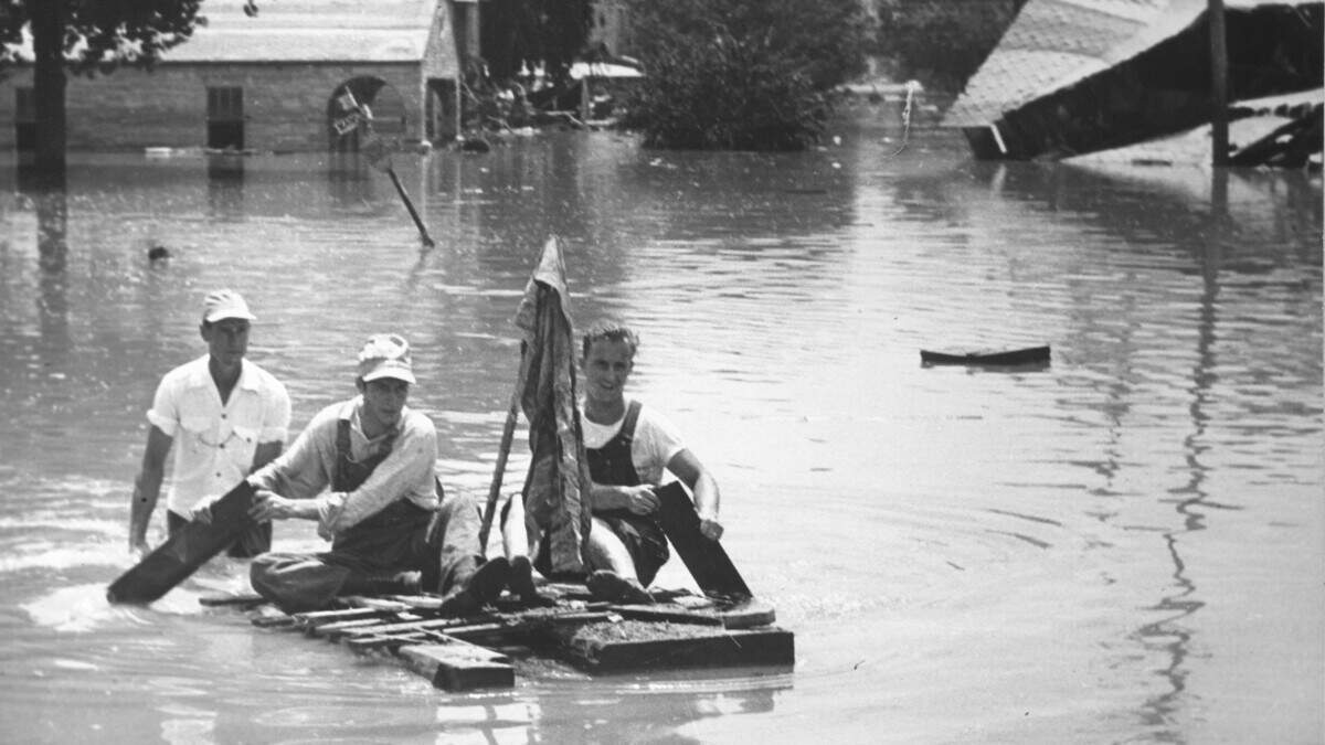
Sirens, horns, and shouts to evacuate rang out in the West Bottoms and along Southwest Boulevard all morning, but the speed of the flooding still caught everyone off guard. Rescuers rowed boats, canoes, and rafts to people trapped in homes and businesses and on rooftops.

Kansas Citians used sandbags, broken concrete, mounds of dirt and rocks from local quarries, and junked cars to shore up the levees protecting Municipal Airport and North Kansas City.
City leaders worried about what would happen when the Kaw’s waters spilled into the Missouri River and ordered residents to evacuate.
Around noon, employers urged Kansans working in downtown KCMO to return home in case the bridges washed out. Auto traffic on the Intercity Viaduct (today’s Lewis and Clark Viaduct) jammed and came to a standstill. Pedestrians ran across on the bridge’s sidewalks.

Adding to the chaos, fires broke out along Southwest Boulevard shortly after 1 p.m. Tanks of oil, gasoline, and other flammable liquids broke free of their supports and floated near 31st Street and Roanoke Road. Oil shimmered off the floodwaters. A spark ignited one of the tanks, and massive clouds of black smoke billowed into the air.

Forced to battle from a distance, firefighters filtered and drafted floodwater to subdue the flames. But each time they contained one fire, another tank exploded, and they would have to begin again. All told, it took 425 firefighters more than three days to extinguish the blazes. Fifteen men were injured, but no deaths were reported.

Fairfax Falls
In Kansas, water incrementally swallowed the Fairfax District. Attention turned to protecting the Board of Public Utilities power and water plant in Quindaro next to the Missouri River. The plant supplied electricity and water to 130,000 residents in Wyandotte and Johnson counties.
.jpg "9. Flooded Fairfax District (10010499).jpg")
Approximately 500 city employees, volunteers, and National Guard members worked from Friday afternoon through the night, trying to hold back the advancing water by erecting a temporary levee around the plant. Concerned the barrier would not hold, the plant manager ordered two more backup levees built closer to the plant.
Workers made a similar effort on the Missouri side. By this time, only the East Bottoms pumping station (located where Nicholson and Indiana avenues used to intersect) supplied water to the entire city, and protecting it was a top priority. In addition to the levee, men stood watch every 1,000 feet along the Missouri River from the Kaw to the Blue River to report weak spots in the flood wall or potential threats to the pumping station. Fortunately, the levees held.

Officials urged residents to conserve water as much as possible. The city manager ordered taverns, theaters, and nonessential retail and service businesses to close for the duration of the shortage and set up public water stations in neighborhoods that had completely lost service. Police patrolled the city, citing those who insisted on washing their cars or watering their yards.
Worried about disease, health officials issued a boil order for neighborhoods that still had running water and recommended that anyone who had been in contact with the floodwaters immediately start a course of typhoid shots at one of several popup clinics.

On Saturday, July 14 at around 3 a.m., the Kaw crested at about 50 feet. The Missouri River crested at approximately 36 feet. The Corps of Engineers confirmed a few hours later that the water was beginning to drop, though progress was slow. Cleanup efforts could not begin in earnest until Tuesday, July 17. The next day, the Turkey Creek station resumed partial operations. Restrictions on water usage began to ease.
.jpg "12a. Columba Tank Company (10010486).jpg")

The cleanup took months. Muck, mud, and debris covered everything.
In the Stockyards, more than 5,000 head of livestock had drowned. The overwhelming stench lingered for weeks, and health officials routinely reminded Kansas Citians that the odor did not carry any disease.

Legacy of the `51 Flood
Remarkably, the loss of human life was minimal; five people reportedly died during the flooding.
Financially though, the cost was enormous. The combined damage along the Kansas River basin and Missouri River was over $800 million. Today, that would amount to more than $10 billion.

The lasting repercussions of the flood were disparate. Much of KCMO had struggled with the immediate water shortage, but it was a grimmer and longer-lasting story on the west side and in KCK. Affected neighborhoods were home to blue-collar workers, most of them Hispanic. The livestock and meat packing industries of the West Bottoms and Armourdale never fully recovered. Thousands of residents lost both their homes and jobs and were forced to leave.

Yet in terms of flood control, the events of 1951 prompted effective changes in the Kansas City area, particularly along the Kaw. A series of 18 dams and water impoundment reservoirs soon sprung up on the river. During the massive flooding of the summer of 1993, those structures were credited with protecting thousands of acres from damage.