Severe thunderstorm warning moving northeast to Clinton and Caldwell counties
UPDATE 6:10 p.m.: A severe thunderstorm warning has shifted northeast to Clinton and Caldwell counties.
The National Weather Service said hazards include golf-ball sized hail and 60 mph winds.
The metropolitan area remains under a flash flood
The Storm Prediction Center in Norman, Okla., has upgraded the chance of severe weather in areas south of Kansas City to moderate risk.
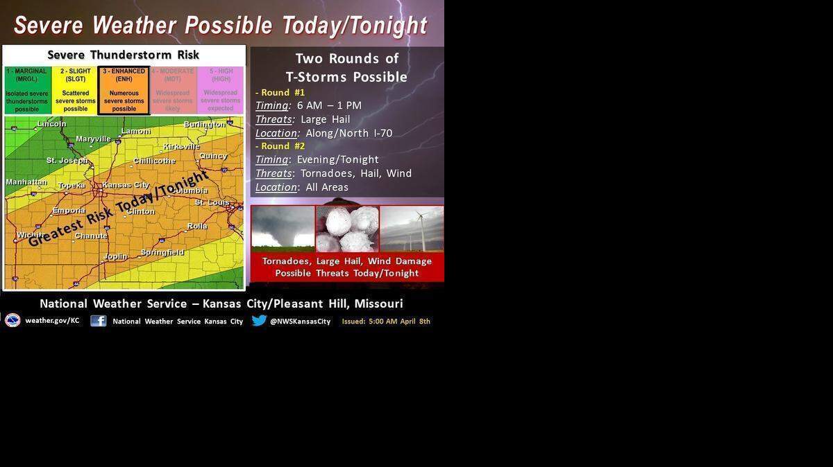
Kansas City still remains under an enhanced risk with the potential for severe weather a possibility across the area. These storms still could produce very large hail, damaging winds and tornadoes.
The storms are expected to develop across eastern Kansas between 4 and 5 p.m.
“It looks like some of the strongest storms will probably end up setting up south of Kansas City primarily,” Mike Bettes, meteorologist for The Weather Channel, said in a phone interview.
Joplin and Springfield appear to be a ripe area for storms.
“It looks like the higher risk for tornadoes at least is going to be southern Missouri,” he said. “When you get down toward Oklahoma, Kansas, Missouri and Arkansas, right in there, that intersection of the four states looks to be a prime target for tornadoes.”
Bettes started the day in Kansas City but headed Joplin when the Storm Prediction Center updated its risk of severe thunderstorms.
While Kansas City remains under a threat of severe thunderstorms, the primary threats appear to be strong winds and hail.
“I think the tornado threat is probably just south of town,” he said. “It’s that typical springtime weather that we get every year. It’s happening again.”
The best potential for severe weather in the Kansas City area is between 5 and 11 p.m., according to the National Weather Service.
Bettes expects a lot of the storms to happen late with the some of the stronger storms after sunset Wednesday night.
“It is going to be a late event for us,” he said. “It may end up being that once people are home, that is when the storms start really cranking.”
Storms may continue after midnight, but the severe threat will be lower.

Kansas City’s storms are part of a severe weather pattern that is affecting the middle part of the country.
A forecaster with the Storm Prediction Center in Norman, Okla., has warned that the ingredients necessary to “blow up some big storms” would fall into place Wednesday and Thursday.
Large hail, damaging winds and tornadoes were possible Wednesday in the southern Plains and then the mid-Mississippi River Valley, including most of Illinois.
The Storm Prediction Center said Wednesday’s storms in an area from Wichita to Joplin and on either side of the Kansas-Oklahoma border could be significant — defined as having 2-inch hail, 75-mph winds and possible tornadoes rated at EF2 or higher.
On Thursday, similar storms were forecast for an area from the Arkansas-Missouri border to southern Wisconsin, including Chicago and St. Louis.
In the Kansas City area, more severe storms are possible early Thursday afternoon, according to the National Weather Service.
Central and eastern Missouri, however, are most likely to experience the severe weather.


The Associated Press contributed to this story.
This story was originally published April 8, 2015 at 8:26 AM with the headline "Severe thunderstorm warning moving northeast to Clinton and Caldwell counties."